Current Projects#
Paving and multimodal improvements are coming to a street near you. Find up-to-date information below about current and planned projects around the city. The projects are intended to facilitate slower traffic speeds and safer roadways for all users including pedestrians, bicyclists, transit riders, people using micromobility devices, and drivers.
-
Centre Ave. Area#
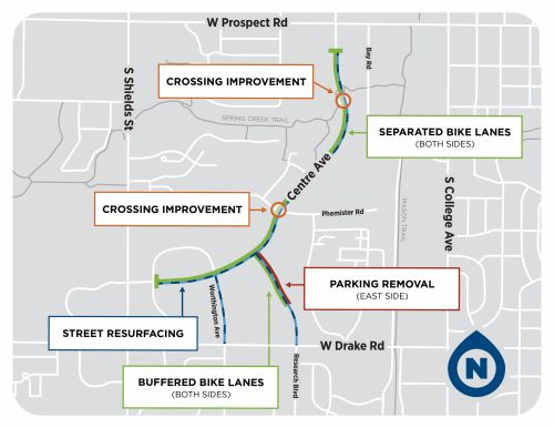
![map of Centre Ave. area transportation improvements]()
Project Overview#
The City completed transportation improvements in the Centre Ave. area in 2024 - 2025. The Centre Ave. area transportation improvements support implementation of the City's Vision Zero Action Plan and Active Modes Plan, which set the ambitious goals of eliminating traffic fatalities and serious injuries by 2032 and achieving 50% active modes share of all trips in support of the City’s broader climate, safety, and equity goals. The improvements covered the following area:
- Centre Ave., from just east of S. Shields St. to just south of W. Prospect Rd.
- Worthington Ave. from Centre Ave. to W. Drake Rd., and
- Research Blvd. from Centre Ave. to W. Drake Rd.
The project included the following key components:
Resurfacing
The City resurfaced the entire work area during this project, improving all pavement conditions.
Traffic safety
Centre Ave. is part of the City's high injury network, which is made up of roads with the greatest share of fatal and serious injury crashes. The Vision Zero Action Plan identifies refuge islands, separated bike lanes, and lane narrowing as safety countermeasures that could help reduce the number of crashes in the top six severe crash types that occur in Fort Collins.
Crossing improvements
In conjunction with the resurfacing, bike and pedestrian refuge islands were constructed along Centre Ave., one at the at-grade crossing of the Spring Creek Trail and two at Rolland Moore Dr./Phemister Rd. Refuge islands (or crossing areas) are medians with a refuge area that is intended to help protect pedestrians and bicyclists who are crossing a road. These improvements were constructed with 2050 tax funding for climate initiatives.
The Spring Creek Trail underpass of Centre Ave. is frequently flooded for weeks to months at a time during the ditch irrigation season. When the underpass is flooded, trail users have to cross Centre Ave. at street level. Rolland Moore Dr. and Phemister Rd. provide an alternative to the often congested Spring Creek Trail. These routes provide connections to Rolland Moore Park, the Walk and Wheel Skills Hub, Sunshine House preschool, CSU Main and South campuses, Mason Trail, Compass Community Collaborative School, and businesses along College Ave.
Bike facility improvements
In conjunction with the resurfacing, on-street parking was removed from the east side of Research Blvd. so that buffers could be added between the bike lanes and vehicular travel lanes. On-street parking on the west side of Research Blvd. was converted to two-hour, time-restricted parking.
Vehicular travel lanes were narrowed along Centre Ave. so that separated bike lanes could be added between the bike lanes and the vehicular travel lanes and to help reduce vehicular traffic speeds. The separated bike lanes were funded with a federal Safe Streets and Roads for All grant. Plastic curbs with integrated plastic delineator posts provide vertical separation between the vehicular travel lanes and the bike lanes. Both Research Blvd. and Centre Ave. are part of the Centre Bikeway, a key corridor in the City's low-stress bicycle network, which provides access to CSU Main Campus and South Campus, the Gardens on Spring Creek, and other key destinations.
Community Meeting#
The City held a hybrid public meeting for community members to learn more about the Centre Ave. area transportation improvements on Thursday, May 16 from 6:00 to 7:00 PM. The meeting was held in person at the Senior Center Lupine room (1200 Raintree Dr.) and online via Zoom.
Contacts#
Cortney Geary | Active Modes Manager, FC Moves | 970-416-2471 | cgeary@fcgov.com
Michael Bussmann | Lead Business Specialist, Economic Health Office | 970-416-2307 | mbussmann@fcgov.com
Jeff Usher | Lead Project Manager, Construction Engineering | 720-270-2653 | jusher@fcgov.com
-
William Neal Parkway/Ziegler Road Intersection Improvements#
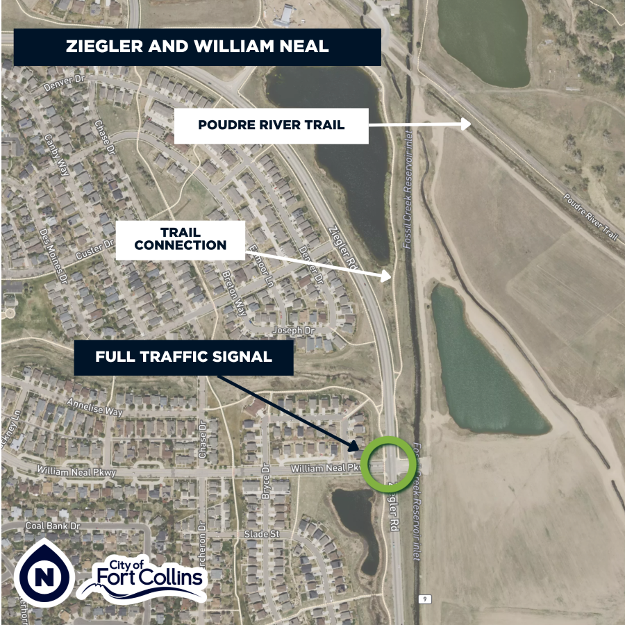
![map of a full traffic signal at the intersection of Ziegler Road and William Neal Parkway]()
Project Overview#
Project: The City is installing a full traffic signal.
Location: William Neal Parkway and Ziegler Road
Construction work period: Beginning fall 2025, complete in 2026
Construction impacts: More information will be available at fcgov.com/construction
The project will include intersection improvements for pedestrians and cyclists to help community members connect to the Poudre River Trail, CSU Environmental Learning Center, Dovetail Park and other key destinations. A crossing improvement at this location was recommended in the City’s Active Modes Plan. The project is funded through a federal Transportation Alternatives grant, Bicycle and Pedestrian Community Capital Improvement Program funds, Transportation Capital Expansion fees and the Conservation Trust Fund.
Contact#
Cortney Geary | Active Modes Manager, FC Moves | 970-416-2471 | cgeary@fcgov.com